2 min read
Fires Erupt in South-Central Chile Image of the Day for January 21, 2026Tens of thousands of people fled to safety as blazes spread throughout the country’s Biobío and Ñuble regions.
NASA Earth Observatory
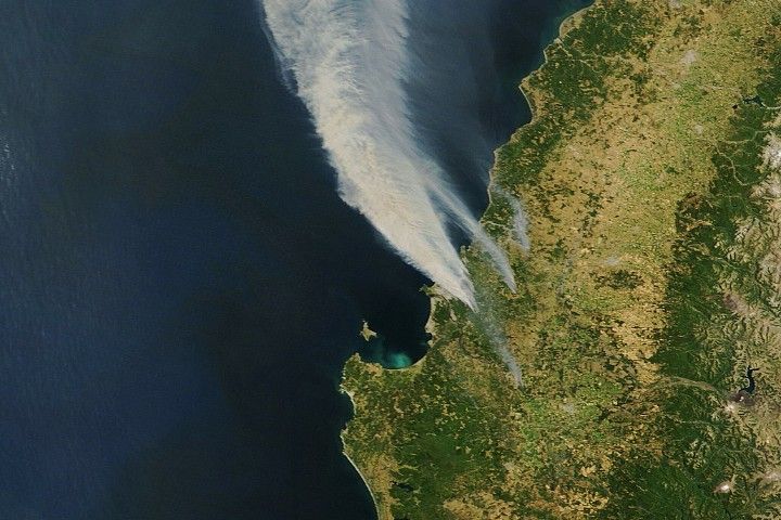
Jan 21, 2026 ArticleWildland fires broke out amid hot and dry conditions in south-central Chile in mid-January 2026, prompting evacuations and causing extensive damage to infrastructure. As of January 20, the spate of deadly fires had burned more than 30,000 hectares (74,000 acres) in the country’s Biobío and Ñuble regions, according to Chile’s National Forestry Corporation.
The MODIS (Moderate Resolution Imaging Spectroradiometer) instrument on NASA’s Terra satellite captured this image of smoke billowing from multiple fires on January 18. Dozens of active fires in the area prompted the evacuation of 50,000 people and destroyed more than 300 homes, according to a January 19 report from Chile’s U.N. Resident Coordinator’s Office. Aerial and ground-based photographs showed neighborhoods in Concepción charred in the aftermath.
Gusty winds, along with temperatures that exceeded 38 degrees Celsius (100 degrees Fahrenheit) in places, fanned the flames and hampered firefighting efforts, according to news reports. Chile’s president declared a state of catastrophe in the Biobío and Ñuble regions, allowing more resources to go toward battling the blazes and assisting affected communities.
Other parts of South America also faced hot and dry conditions during the 2025–2026 summer, likely priming vegetation to burn. About 650 kilometers (400 miles) south of Concepción, firefighters in Argentina battled wildfires in and around Los Alerces National Park, home to rare stands of long-lived cypress trees.
NASA Earth Observatory image by Lauren Dauphin, using MODIS data from NASA EOSDIS LANCE and GIBS/Worldview. Story by Lindsey Doermann.
References & Resources
- CONAF (2026, January 20) Situacion Actual Incendios Forestales. Accessed January 20, 2026.
- The Guardian (2026, January 18) Chilean president declares state of catastrophe as wildfires kill at least 18. Accessed January 20, 2026.
- NASA (2026) Fire Information for Resource Management System. Accessed January 20, 2026.
- NASA Earth Observatory (2026, January 12) Fire Threatens Rare Forests in Argentina. Accessed January 20, 2026.
- The New York Times (2026, January 18) ‘Come Help Us’: Wildfires Grip Parts of Chile, Killing at Least 18. Accessed January 20, 2026.
- ReliefWeb (2026, January 20) Reporte de Situación N°1 Incendios Forestales – Enero 2026 (al 19 de enero, 15hrs CL). Accessed January 20, 2026.
Downloads
January 18, 2026
JPEG (757.81 KB)
You may also be interested in:
Stay up-to-date with the latest content from NASA as we explore the universe and discover more about our home planet.
Fire Threatens Rare Forests in Argentina 3 min readBlazes spread across Los Alerces National Park, home to some of the world's oldest trees.
Article Smoky Skies in the Pacific Northwest 3 min readSmoke filled river valleys in northeastern Washington and parts of British Columbia.
Article Seeing the Monroe Canyon Fire in a New Light 5 min readAs wildland fires raged in the American West, NASA airborne technology was there to image it in incredible detail.
Article Keep ExploringDiscover More from NASA Earth Science
Subscribe to Earth Observatory Newsletters
Subscribe to the Earth Observatory and get the Earth in your inbox.
Earth Observatory Image of the Day
NASA's Earth Observatory brings you the Earth, every day, with in-depth stories and stunning imagery.
Explore Earth Science
Earth Science Data