6 min read
Mapping Earth’s Observations, featuring Betsy FordSondra Woodward
Jun 29, 2026 ArticleContents
- Decision analyst Betsy Ford Credit: NASA
“It reaches more people than most realize. The farmers who are growing your food use the data from these satellites.”
“ESD leadership is constantly navigating this complicated landscape,” says Betsy Ford, a decision analyst and Deputy Team Lead for the NASA Earth Science Strategic Integration Environment (NESSIE) team within the Systems Analysis and Concepts Directorate (SACD) at NASA’s Langley Research Center. “Our work focuses on integrating information across the broad system-of-systems so that these decision-makers can visualize the current state, how things could evolve, and how all of it lines up against NASA’s long-term scientific priorities.”
A Detour Through Detroit
Ford’s path to this work runs through two vastly different worlds, and it all started before she could even drive.
Both of her parents spent their careers at NASA Langley and recently retired from it. Growing up, Ford attended the center’s daycare and its summer picnics. “It always felt like a college campus and a big family,” she says. “I really loved that.”
Betsy Ford (in blue gown) and family celebrate her kindergarten graduation at NASA Langley. Credit: Betsy FordStill, when she graduated from Virginia Tech with a mechanical engineering degree, she chose to branch out first. She joined General Motors’ engineering rotation program in Michigan, spending time as a mass integration engineer for Corvette before moving to work as a vehicle occupant safety engineer performing crash testing. She was also finishing a master’s in engineering management at the University of Nebraska, where she was introduced to risk analysis and strategic decision making.
When a position opened in the Space Mission Analysis Branch (part of SACD), she applied, hoping her experience in systems engineering and master’s might offset the gap between the hardware testing of running vehicles into walls and the analytical work NASA needed. “Leadership saw potential in my background and gave me a chance to apply it in a new context,” she says.
Betsy Ford (second from right) and family gather at NASA Langley’s front gate. Credit: Betsy FordFinding the Story in the Data
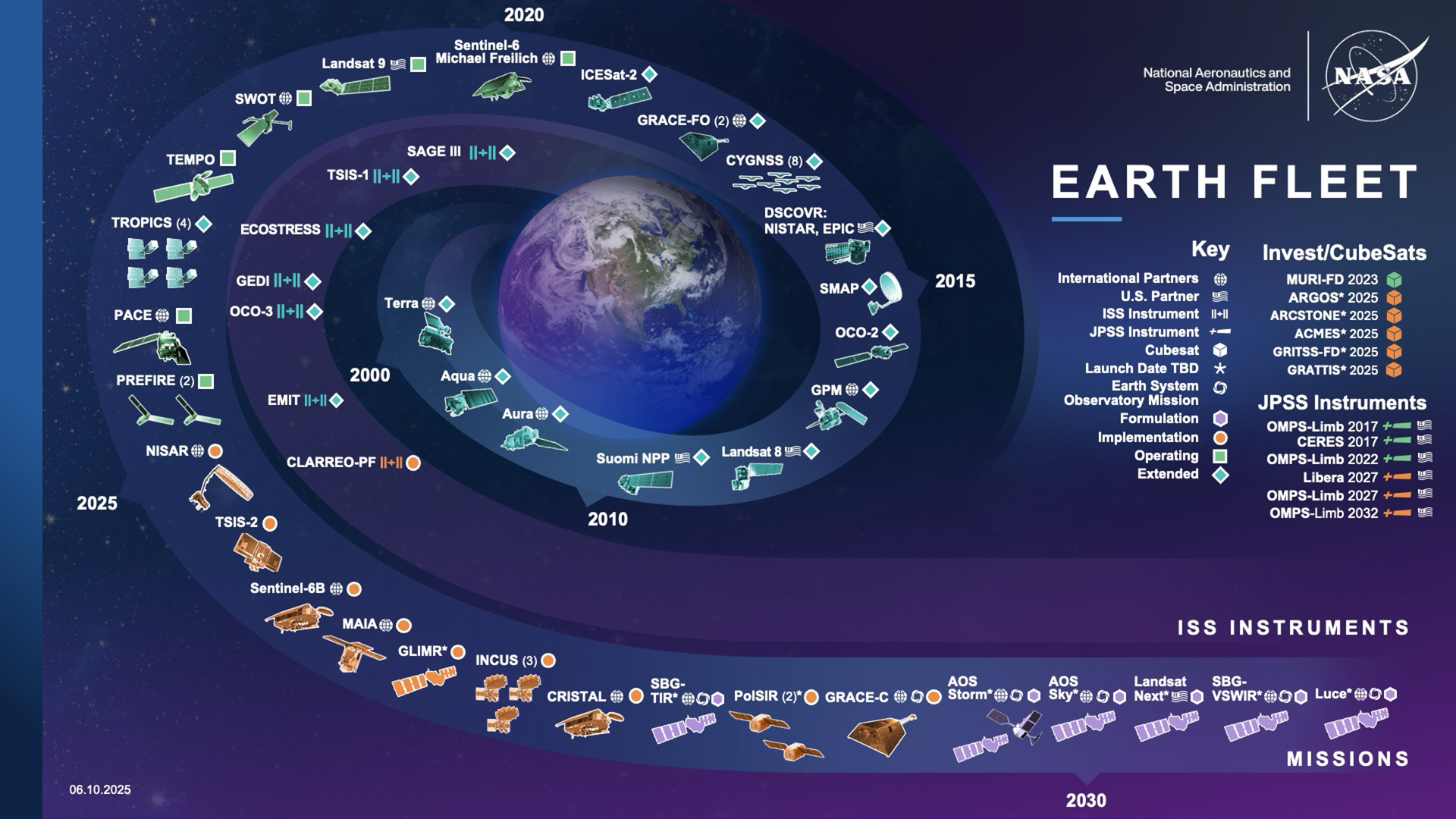
At its core, NESSIE addresses an information architecture problem. Hundreds of Earth-observing satellite missions, both NASA’s and its partners,’ each observing specific phenomena, from cloud cover to land use. That data has always existed. The challenge was making sense of it all in one place.
NESSIE’s main web application page presents a heat map showing which missions are addressing 34 science observables alongside a mission timeline. Additional views drill down further, such as which specific instruments on which spacecraft cover a given measurement, and how international partner collaborations have evolved over the years.
This graphic shows the fleet of NASA Earth Science missions, which provide hundreds of measurements and data products to understand the Earth system. Credit: NASA“We focus on continuous improvement,” Ford explains. “Each iteration aims to give our stakeholders a clearer, more useful product than they had the day before.” While supporting NASA headquarters in its strategic planning, the team is working toward making NESSIE available to the National Academies to help inform the next decadal survey, a document that will define national science priorities and guide government investments into the next decade. It’s a milestone that Ford describes as a significant step toward “using NESSIE to more fully support the scientific community through clearer>