2 min read
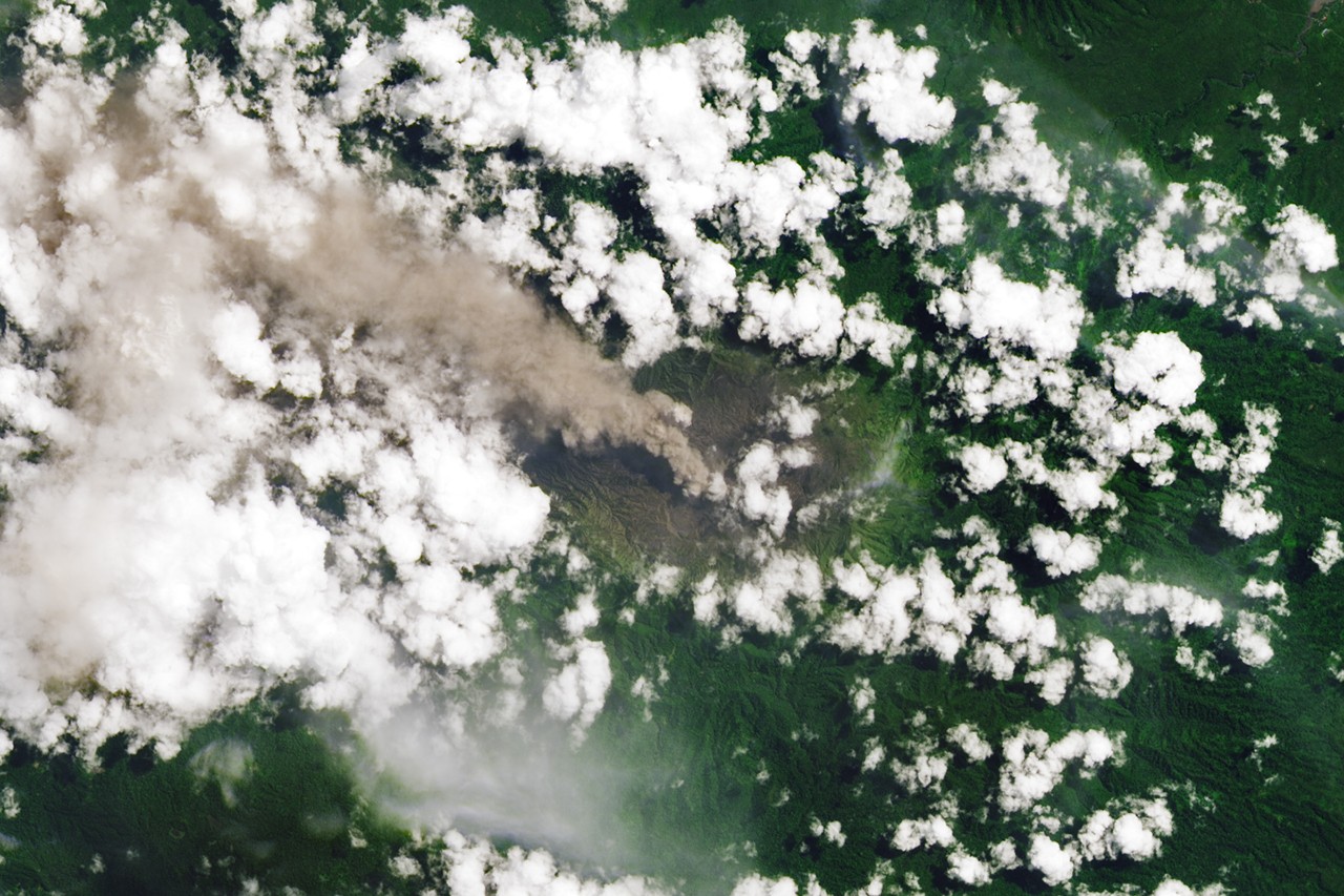
Ever Restless Mount Dukono EruptsImage of the Day for May 27, 2026The volcano on Indonesia’s Halmahera Island routinely ejects ash, volcanic gases, and volcanic bombs.
NASA Earth Observatory
May 27, 2026 ArticleIn May 2026, the Global Volcanism Program reported nine actively erupting volcanoes in Indonesia—more than any other country at the time. Such activity is typical for the Southeast Asian archipelago, where eruptions have occurred at 55 volcanoes since the 1960s—the highest total for any country. Japan ranks second with eruptions at 40 volcanoes over that time period, followed by the United States with 39, according to Global Volcanism Program data.
Even for such an eruption-prone country, the persistence of activity at Mount Dukono stands out. The remote stratovolcano, located at the northern end of Halmahera Island, has been erupting nearly continuously since 1933, with near-daily rumbles and frequent emissions of ash and volcanic gases. The volcano routinely flings hunks of semi-molten rock, known as volcanic bombs, hundreds of meters from its vent.
This sort of activity at Dukono turned deadly on May 8, 2026, when ash and volcanic bombs rained down on a group of hikers. In the days following the tragedy, the mountain remained highly active. Indonesia's volcanological survey reported an average of 52 eruptive events per day between May 9 and 16, with ash plumes rising 400 to 4,300 meters (1,300 feet to 14,000 feet) above the summit.
NASA and other U.S. government satellites detected thermal anomalies, ash plumes, and sulfur dioxide emissions in recent days. Indonesian authorities have set the alert level at 2 (on a scale of 4) and warned the public to stay at least 4 kilometers (2 miles) from the crater.
NASA Earth Observatory image by Lauren Dauphin, using Landsat data from the U.S. Geological Survey.Story by Adam Voiland.
Downloads
May 13, 2026
JPEG (4.34 MB)
References & Resources
- Center for Volcanology and Geological Hazard Mitigation (2026) MAGMA Indonesia. Accessed May 26, 2026.
- CNN (2026, May 9) Multiple hikers killed, others rescued after volcano erupts in Indonesia. Accessed May 26, 2026.
- Global Volcanism Program (2026, May 14) Weekly Volcanic Activity Report. Accessed May 26, 2026.
- Global Volcanism Program (2026, March 31) Which countries have the most volcanoes? Accessed May 26, 2026.
- The Ministry of Energy and Mineral Resources (2026) Gunung Dukono Kembali Erupsi, Masyarakat Diminta Waspadai Sebaran Abu Vulkanik. Accessed May 26, 2026.
- Mirova (2026, May 26) Dukono. Accessed May 26, 2026.
- Mounts (2026, May 26) Dukono. Accessed May 26, 2026.
- Oregon State University (2026) Dukono. Accessed May 26, 2026.
You may also be interested in:
Stay up-to-date with the latest content from NASA as we explore the universe and discover more about our home planet.
Home Reef Adds On 3 min readThe Tongan volcano expanded its mid-Pacific real estate during its latest eruptive phase.
Article A Volcanic Medley Near Mammoth Lakes 4 min readA massive, old caldera and more recently formed craters shape the landscape in the eastern Sierra Nevada.
Article Scoria Cones on Earth and Mars 7 min readThe hill-shaped features are a sign of explosive volcanic activity—a rarity on the Red Planet.
Article Keep ExploringDiscover More from NASA Earth Science
Subscribe to Earth Observatory Newsletters
Subscribe to the Earth Observatory and get the Earth in your inbox.
Earth Observatory Image of the Day
NASA's Earth Observatory brings you the Earth, every day, with in-depth stories and stunning imagery.
Explore Earth Science
Earth Science Data
Open access to NASA’s archive of Earth science data