4 min read
Melting Snow Off ShivelyuchImage of the Day for May 6, 2026Near-constant activity continues on the volcano in Russia.
NASA Earth Observatory
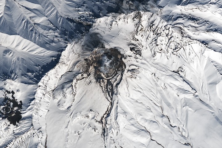
May 06, 2026 ArticleShivelyuch (also called Shiveluch), the most northerly active volcano on the Kamchatka Peninsula, is one of the most active volcanoes in the world. On a near-daily basis, satellites detect new signs of activity within its horseshoe-shaped caldera, including thermal anomalies, hot avalanches and debris flows, and ash deposits that darken the surrounding landscape.
The Landsat 9 satellite captured this image of the towering volcano—one of the largest and tallest on the peninsula—on April 23, 2026, a day when fresh activity left its mark on the snowy, late-spring landscape. A multi-lobedplug of viscous lava called a lava dome—appearing as a dark patch in the caldera—has been actively growing in recent months, according to reports from the Kamchatka Volcanic Eruption Response Team (KVERT). Dome-building lava is typically extruded slowly and piles up into lobed, sloped, or spine-like shapes akin to those that form when toothpaste is squeezed from a tube.
The caldera contains a growing lava dome and signs of block-and-ash flows in channels radiating outward in this detailed image, acquired April 23, 2026, by the OLI (Operational Land Imager) on Landsat 9.NASA Earth Observatory / Lauren DauphinOn Shivelyuch, lava domes cycle through periods of growth and collapse, frequently producing explosive bursts of ash and launching avalanches of hot ash and soil called pyroclastic flows when they collapse. Debris slides through structures that Alina Shevchenko, a volcanologist with the GFZ Helmholtz Centre for Geosciences, called "avalanche chutes" and "lahar channels" radiating outward from the caldera. Collapses can trigger events geologists call “block-and-ash flows," which typically contain coarse, blocky chunks of cooled volcanic rock along with powdery volcanic ash and soil.
Such flows often produce thick, insulating deposits that retain heat for long periods, sometimes even months or years, melting snow in the winter months. As seen in the Landsat images above, this activity leaves dark channels and exposed patches that contrast with the surrounding snow cover.
Satellites have regularly detected thermal anomalies within the caldera and near the recent months, as well as warm land surface temperatures along the network of channels. On the day the image was acquired, KVERT reported that the "explosive-extrusive eruption" of the volcano continued, accompanied by "powerful gas-steam activity."
An unusually large eruption and flank collapse in April 2023 sent massive pyroclastic flows barreling tens of kilometers down the mountain, destroying vast swaths of forest and leaving large deposits and flow channels near the foot of the mountain that are still visible today. “It’s quite possible that those deposits still retain some heat from that event,” said Janine Krippner, a geologist based in New Zealand. Krippner noted that when she did field research on Shivelyuch block-and-ash flows in 2015, she could still feel the heat within deposits that were five years old.
"Shivelyuch is an incredible volcano that has collapsed over and over again, on several scales, ranging from enormous flank collapses to more modest dome-collapse events," Krippner said. "It goes through cycles of collapse but then builds itself up again and again through constant volcanic activity," she added. "It should really be on a motivational poster."
NASA Earth Observatory image by Lauren Dauphin, using Landsat data from the U.S. Geological Survey. Story by Adam Voiland.
Downloads
April 23, 2026
JPEG (7.84 MB)
References & Resources
- Global Volcanism Program (2026) Sheveluch. Accessed May 5, 2026.
- Grishin, S.Y., et al. (2025) Impact of the Major Eruption of the Shiveluch Volcano (April 2023, Kamchatka) on Ecosystems: The Extent of Forest Burial and Damage Based on Satellite Data. Izvestiya, Atmospheric and Oceanic Physics, 61, 1129–1136.
- Krippner, J.B., et al. (2018) Parametric analysis of lava dome-collapse events and pyroclastic deposits at Shiveluch volcano, Kamchatka, using visible and infrared satellite data. Journal of Volcanology and Geothermal Research, 354, 115-129.
- Krippner, J.B., et al. (2018) Exceptionally large block-and-ash flows: a detailed study of the 2005 and 2010 eruption deposits of Shiveluch volcano. EarthArXiv preprint.
- NASA Earth Observatory (2023, April 12) Kamchatka Erupts. Accessed May 5, 2026.
- NASA Earth Observatory (2011, January 25) Activity at Shiveluch Volcano. Accessed May 5, 2026.
- Shevchenko, A., et al. (2021) Constructive and Destructive Processes During the 2018–2019 Eruption Episode at Shiveluch Volcano, Kamchatka, Studied From Satellite and Aerial Data. Frontiers in Earth Science Volcanology, 9, 680051.
- Zharinov, N.A. & Demyanchuk, Y.V. (2024) The April 11, 2023 Catastrophic Explosive Eruption of Sheveluch Volcano, Kamchatka. Journal of Volcanology and Seismology, 18, 1–9.
You may also be interested in:
Stay up-to-date with the latest content from NASA as we explore the universe and discover more about our home planet.
Eruption at Mayon 3 min readActivity at the volcano in the Philippines sent lava and pyroclastic flows down the volcano’s flanks and prompted evacuations in…
Article Restless Kīlauea Launches Lava and Ash 3 min readEpisode 43 of the Hawaiian volcano’s current eruption was marked by high lava fountains and widespread ash dispersal.
Article Scoria Cones on Earth and Mars 7 min readThe hill-shaped features are a sign of explosive volcanic activity—a rarity on the Red Planet.
Article Keep ExploringDiscover More from NASA Earth Science
Subscribe to Earth Observatory Newsletters
Subscribe to the Earth Observatory and get the Earth in your inbox.
Earth Observatory Image of the Day
NASA's Earth Observatory brings you the Earth, every day, with in-depth stories and stunning imagery.
Explore Earth Science
Earth Science Data
Open access to NASA’s archive of Earth science data